Geomatics
Aprende a Convertir Coordenadas Geográficas en UTM y UTM En
Longitude / Geodesy
Aprende a Convertir Coordenadas Geográficas en UTM y UTM en Geográficas
Geomatics / Geography
Reseña Del Establecimiento de La Red de Triangulación Nacional
Geomatics / Scientific Observation
nivelación topográfica
Geomatics / Geodesy
PLANEACION SEXTO GEOG
Map / Continent
Topogra. Triangulacion OK 1b
Azimuth / Topography
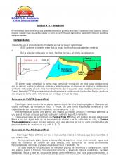
nivelacion
Geomatics / Surveying

Triangulación Final
Triangle / Topography

Elementos Teoricos Sobre La Altimetria
Geomatics / Geometry

Coordenadas y Gps
Global Positioning System / Geomatics

Informe de Nivelacion Compuesta
Topography / Geodesy
Conversión de Coordenadas
Latitude / Geomatics

Ajuste y Balance de La Nivelacion
Topography / Geomatics
practicas de Topografia
Geomatics / Equipment
nivelacion radial.docx
Surveying / Mathematical Analysis

ESTACIÓN LIBRE Y REPLANTEO
Topography / Surveying
Trabajo Topografia Presentacion
Geodesy / Cartography
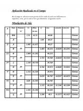
Inf. 08 Nivelacion Compuesta
Surveying / Geomatics
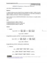
Lectura Complement Aria 3 Replanteo y Calculo de Volumenes[1]
Topography / Geography
Levantamiento Topografico Campañac Por Radiacion
Topography / Global Positioning System
LEVANTAMIENTO TOPOGRÁFICO: INTRUMENTOS Y AVANCE ALCANZADO HASTA NUESTROS DÍAS
Geographic Information System / Topography
d Nivelacion
Geodesy / Earth
ENCUADRE DEL CURSO DE TOPOGRAFÍA 2012
Topography / Geomatics
