Geomatics
Determinacion de Rumbo y Azimut de Una Poligonal Abierta
Azimuth / Geomatics
Diplomado en Topografia 2
Topography / Geodesy
Significado y Uso de Coordenadas
Longitude / Coordinate System
Topografia Para Ingenieros Civiles i
Topography / Geomatics
Aplicación en El Campo Del Tema de Triangulación y de Photenot
Measuring Instrument / Geomatics
Problemas de Escalas (Word)
Fraction (Mathematics) / Longitude
La Escala y Problemas
Map / Topography
Evaluacion Sistema de Coordenadas Geograficas
Equator / Earth
Nivelación.pdf
Topography / Scientific Observation
Instrumentacion Topografia Tesco
Topography / Surveying

Nivelación
Geomatics / Scientific Observation
Resumen Transformacion Datum-coordenadas
Coordinate System / Topography
Topografia - Lista de exercícios 2(1)
Geodesy / Scientific Observation
Levantamiento Topografico
Topography / Global Positioning System
Levantamiento+Topográfico
Topography / Geomatics

Que es topografía
Topography / Geodesy
A.- Resumen Ejecutivo de Topografia, Trazo y Diseño vial
Geodesy / Geomatics
LEVANTAMIENTO TOPOGRAFICO
Topography / Geomatics
Examenes de Topografia
Visual Journalism / Geomatics
3 INFORME (Nivelacion Circuito Cerrado)
Topography / Earth & Life Sciences
La topografía
Topography / Geodesy
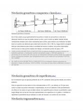
Nivelación Geométrica Compuesta o Lineal
Geodesy / Surveying